This article was last updated on April 16, 2022
Canada: ![]() Oye! Times readers Get FREE $30 to spend on Amazon, Walmart…
Oye! Times readers Get FREE $30 to spend on Amazon, Walmart…
USA: ![]() Oye! Times readers Get FREE $30 to spend on Amazon, Walmart…
Oye! Times readers Get FREE $30 to spend on Amazon, Walmart…
With President Trump signing an executive order that rolls back the Obama Administration’s climate change policies, recent data from the National Snow and Ice Data Center is particularly interesting. The Energy Independence Executive Order puts an end to the “war on coal” by curtailing the Environmental Protection Agency’s regulations restricting greenhouse gas emissions sourced from coal-fired power plants. The EPA has been directed to formally consider repealing the Clean Power Plan, the centrepiece of the Obama Administration’s 2015 plan to cut the power sector’s 2005 level carbon dioxide emissions by 32 percent by 2030 as shown here:
“Review of the Environmental Protection Agency’s “Clean Power Plan” and Related Rules and Agency Actions. (a) The Administrator of the Environmental Protection Agency (Administrator) shall immediately take all steps necessary to review the final rules set forth in subsections (b)(i) and (b)(ii) of this section, and any rules and guidance issued pursuant to them, for consistency with the policy set forth in section 1 of this order and, if appropriate, shall, as soon as practicable, suspend, revise, or rescind the guidance, or publish for notice and comment proposed rules suspending, revising, or rescinding those rules. In addition, the Administrator shall immediately take all steps necessary to review the proposed rule set forth in subsection (b)(iii) of this section, and, if appropriate, shall, as soon as practicable, determine whether to revise or withdraw the proposed rule.”
Coincidentally, the National Snow and Ice Data Center (NSIDC) just released its analysis of sea ice conditions in the Arctic. Here is a summary of their findings.
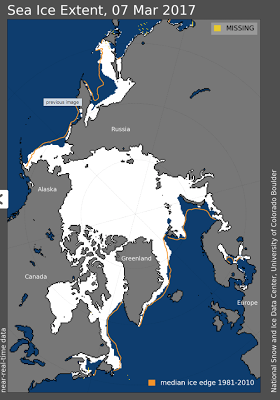
Arctic sea ice appears to have reached its winter season maximum on March 7, 2017, the lowest maximum in the 38-year satellite record. The maximum extent was 14.42 million square kilometres (5.57 million square miles), 7.8 percent smaller than the 1981 to 2010 average maximum of 15.64 million square kilometres (6.04 million square miles). This year’s maximum is also 97,000 square kilometres (37,000 square miles) smaller than the previous lowest maximum which occurred on February 25, 2015.
Here is a map showing the Arctic sea ice aerial extent on March 7, 2017 compared to the median extent for the years between 1981 and 2010 as shown on the orange line:
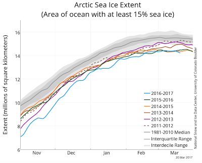
Here is a graph showing the Arctic sea ice extent (the area of the ocean with at least 15 percent sea ice) for the past 6 years as well as the median for the period between 1981 and 2010:
The extent of Arctic sea ice is substantially below the long-term median as shown on the grey line and, for the most part of the winter, was at the lowest levels since the 2011 – 2012 season
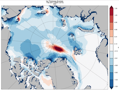
Let’s now look at Arctic sea ice volume. Not only is the sea ice less aerially extensive, it is thinner as shown on this map from the Polar Science Center which shows thicker than normal ice in red and thinner than normal ice in blue:
Sea ice is thinner over much of the Arctic, particularly in the region north of Greenland and Ellesmere Island, a region that has historically had the thickest ice in the Arctic.
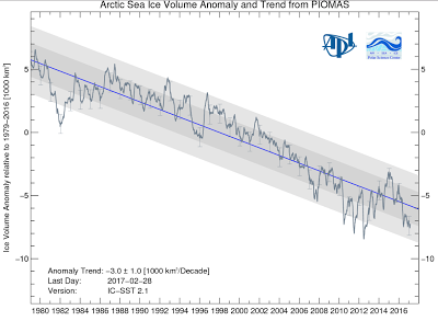
Obviously, reduced ice thickness and reduced ice aerial extent will have an impact on the total volume of Arctic sea ice. The volume of Arctic sea ice volume is calculated using the Pan-Arctic Ice Ocean Modelling and Assimilation System (PIOMAS) from the Polar Science Center. Ice volume anomalies for each day are calculated relative to the average volume over the period between 1979 and 2016 for that day of the year; This removes the annual cycle of ice volume growth and shrinkage. According to PIOMAS, the model mean annual of sea ice volume over the years between 1979 and 2016 ranges from 28,000 cubic kilometres in April to 11,500 cubic kilometres in September. Here is a graphic showing the Arctic sea ice volume from PIOMAS:
Please note that the areas shaded grey on the graphic represent the one and two standard deviation of the residuals of the anomaly from the trend as shown with the blue line. In February 2017, Arctic ice volume was measured at 17,400 cubic kilometres, the lowest volume on record and 42 percent below the maximum February ice volume in 1979. As well, it was 30 percent below the 1979 to 2016 mean and nearly 2000 cubic kilometres below the previous record set in 2013.
While a significant percentage of Americans believe that climate change is a hoax, and in the case of Donald Trump, a hoax perpetrated by the Chinese, what if climatologists are right and the world is changing? The changes in Arctic sea ice areal extent and volume may just be the “canaries in the climate change coal mine” that are telling us that something is changing. What happens when it’s too late to make the changes that will prevent further damage to the delicate ecology of the oblate spheroid that humans (and other beings) call home?
Click HERE to read more.
Vote for Shikha Dhingra For Mrs South Asia Canada 2017 by liking her Facebook page.
You can publish this article on your website as long as you provide a link back to this page.


Be the first to comment