This article was last updated on April 16, 2022
Canada: ![]() Oye! Times readers Get FREE $30 to spend on Amazon, Walmart…
Oye! Times readers Get FREE $30 to spend on Amazon, Walmart…
USA: ![]() Oye! Times readers Get FREE $30 to spend on Amazon, Walmart…
Oye! Times readers Get FREE $30 to spend on Amazon, Walmart…
While a significant portion of the population doesn't believe in the concept of global warming and its consequences, what if it really happened? What would the impact be on the coastal United States? A study by researchers at the Rosenstiel School of Marine and Atmospheric Science looks at the possible impact on one of America's largest cities, Miami.
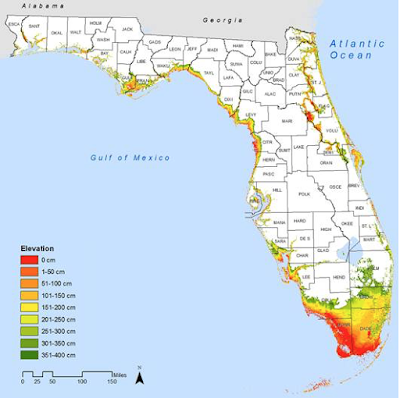
Let's open with a map showing the coastal elevations in Florida:
As we can easily see, a very significant area of southern Florida is barely above sea level.
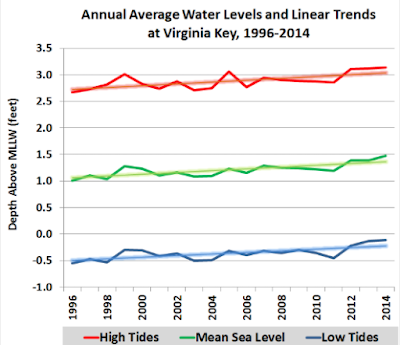
Let's now look at the changes in sea level in the Miami area. Since 1996, measurements of sea level taken on the small island of Virginia Key located south of Miami Beach show the following trend:
By 2014, mean sea level has risen by 3.7 inches from their 1996 levels.
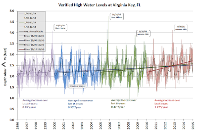
Not only is sea level rising in the Miami area, the rate of the rise is accelerating as shown on this graphic which plots the daily highest tide mark. Please note that each five year period is given a different colour:
Note that the slope of the line that is calculated using a 31 day running mean of all 19 years of data. Over the past 15 years, the average high tide has increased by 0.3 inches per year, however, over the past 5 years, the high tide level has increased at an average rate of 1.27 inches per year.
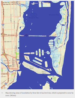
What does all of this mean to the Miami metropolitan area, home to just over 5.5 million people? More than 10 percent of land in Miami-Dade lies at least than 1 foot above sea level, 20 percent at less than 2 feet and 25 percent at less than 3 feet. Here is a map showing how much of central Miami will be inundated at high tide with a three foot rise in sea level:
As well, the same area would be flooded during significant rain events (i.e. hurricanes) during even the lowest of tides.
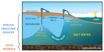
Miami is suffering from a two-edged sword. Municipal wells that provide water for both residential and agricultural use are pumping water from a porous and permeable limestone aquifer. As shown in this diagram, as the fresh water is pumped out of the aquifer, saltwater from the ocean advances into the aquifer in a process known as saltwater intrusion:
As a result of saltwater intrusion, some cities in Florida have had to shut down some of their fresh water wells because the water has become contaminated (brackish). As sea level rises over the coming decades, the saltwater will exert more pressure on the freshwater in the aquifer, pushing the freshwater further from the coast and toward the surface. This means that the depth to the water table will decrease as time passes. Another problem connected to the porosity of the bedrock underlying south Florida is that seawalls cannot block seawater; during storm surges, seawater will move inland under any seawalls that are constructed.
A study by Forbes Thompson and Christina DeConcini at the World Resources Institute observes that sea level in southeast Florida has risen by 12 inches with the annual se level rise between 1993 and 2010 being twice the rate that was observed from 1901 to 2010.
Over the next 20 years, Florida's problems with sea level changes will become more apparent. By 2034, sea level is expected to rise by about 6 inches meaning that flooding from heavy rains will become more of a problem, particularly for residents that live very close to sea level. By 2060, sea levels along Florida's coastline will rise by between 9 inches and two feet. This will have a massive impact on Florida's economy as the cost of post-storm cleanups increase in lock-step with the damage being done. To give us a sense of the size of the problem, the 2005 Hurricane Wilma caused $2.21 billion in damage to the Miami-Dade area. The seven foot storm surge that caused this amount of damage had the likelihood of occurring only once in 76 years. If the sea level along Miami-Dade's coastline rises by one foot, the same seven foot storm surge will have a likelihood of occurring once in 21 years and if the sea level rises by two feet, the same seven foot storm surge would have a likelihood of occurring once every five years!
Florida is the most vulnerable state to changes in sea level and Miami-Dade has more people living less than four feet above sea level than any other state excluding Louisiana. Miami has the nation's largest amount of exposed assets and has the world's fourth largest population vulnerable to a rising sea level. Whether the cause of global climate change is related to man-made/anthropogenic causes or is just part of a natural warming cycle it matters little to the future residents of Miami and Dade County. It's not a political issue. It's an issue that will impact us all, particularly given that billions of dollars worth of homes and infrastructure lie within the target zone.
Click HERE to read more of Glen Asher's columns
You can publish this article on your website as long as you provide a link back to this page.

Be the first to comment