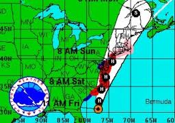
 Irene is severely weakened but is still packing a wallop. With sustained winds of 75 mph (120 km/h), the storm is continuing to head up the coastline. The latest forecasts are saying that Irene will move over New York late Sunday morning. It is expected to move inland over southern New England Sunday afternoon.
It has now left behind North Carolina and Virginia to clean up in its wake having knocked down power lines and blowing out transformers. Reports say that over 700,000 outages have left three million customers in the dark. With the worst behind them, residents can now survey the damages and start the work of getting their areas back to normal.
Preparing for the worst, New York City shut down the MTA, the nation’s largest mass transit system. All New York City Subway, bus, and commuter rail service was halted at noon on August 27. A mandatory evacuation order was issued for anyone in low-lying areas on August 26 with New York City Mayor Michael Bloomberg announcing that the city would prepare to create an “an enormous shelter system” for residents without access to higher ground. ABC reports that approximately 9,600 are currently in evacuation shelters.
In lower Manhattan at Wall Street and South Street water from New York’s East River is already breaching the seawall. Work crews are swarming the area attempting to halt water from shoving down the streets, where it could affect transformers in lower Manhattan and flow into the subway system.
ABC: Storm Tracker: an up-to-date map of Hurricane Irene; where it is and the predicted path
Al Jazeera reports that the storm will cross the border into eastern Canada on Sunday night. By that time, it should be just a vigorous area of low pressure. This means that the weather in Canada will not be as bad as that in the US, but there are still warnings in force in the country for heavy rain, strong winds and a storm surge for coastal areas.
The Canadian Hurricane Centre is warning that a shift in the exact track or intensity of the storm is unimportant, as Irene is such a large system with far-reaching impacts. Residents are urged to start making preparations immediately.
Published on Aug 28, 2011 by AssociatedPress
Irene Batters Mid-Atlantic, Heads for NYC
Hurricane Irene battered the North Carolina and Mid-Atlantic coast, dumping heavy rain and high winds as it moved, and killing at least 8 people. The storm is now headed to New York City as a weakened Category 1 storm. (Aug. 28)
Published on Aug 27, 2011 by AssociatedPress
Irene Rakes East Coast, Millions in Path
Hurricane Irene opened its assault on the Eastern Seaboard on Saturday by lashing the North Carolina coast with wind as strong as 115 mph. Now, millions along the East Coast are watching where the storm will tread next. (Aug. 27)
Click HERE to read more from William Belle
Article viewed at: Oye! Times at www.oyetimes.com

Be the first to comment