This article was last updated on April 16, 2022
Canada: ![]() Oye! Times readers Get FREE $30 to spend on Amazon, Walmart…
Oye! Times readers Get FREE $30 to spend on Amazon, Walmart…
USA: ![]() Oye! Times readers Get FREE $30 to spend on Amazon, Walmart…
Oye! Times readers Get FREE $30 to spend on Amazon, Walmart…
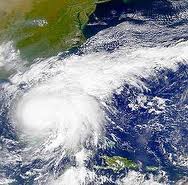
 Batten down the hatches! Here it comes, folks. With winds reportedly at 110 mph (175 km/h), areas of the coast which are not used to seeing hurricanes are going to have the unexpected arrive with Mother Nature unleashing while not her best enough to cause for alarm. Predictions have the storm making landfall in North Carolina on Saturday then moving up the coast to New York for Sunday. Storm surges will apparently be from six feet to 12 feet (2 metres to four metres).
The storm presents some unusual problems. For starters, it is uncommonly large. Hurricane-force winds of at least 75 mph (120 km/h) extend 90 miles (144 km) from its centre with winds of 40 mph extending as far out as 290 miles (466 km). Secondly it is moving slowly, only around 14 mph (23 km/h). Similar storms usual travel at speeds of 30 to 40 mph (48 to 64 km/h). Forecasters are saying that the size and slow pace could lead to greater flooding in the Middle Atlantic States and in the Northeast where heavy rains this summer have already left the ground saturated in places.
At the moment, Irene is a category two hurricane. The experts haven’t agreed on what’s going to happen over the next few days but some are seeing the storm getting stronger. Will Irene move up to a category three or four? Some news outlets are making those predictions and if true, those in the path are going to experience an even harder time of it dealing with this storm.
At the moment, off the coast of North Carolina, the Outer Banks are being evacuated. Other areas are declaring state of emergencies to prepare for what’s expected to be intense flooding. New York is going to shut down its transit system at some point on the weekend and Washington, which was going to have President Obama giving an address on Sunday for the dedication of a new memorial to Martin Luther King Jr., will see the event postponed.
In Canada the federal government has issued a travel advisory against all non-essential travel to the East Coast of the United States. The Department of Foreign Affairs writes on their web site:
Foreign Affairs and International Trade Canada advises against non-essential travel to the east coast of United States, from Little River Inlet in North Carolina northward to Sandy Hook in New Jersey, including The Pamlico, Albemarle, Currituck Sounds, Delaware Bay and Chesapeake Bay south of Smith Point, and from Sandy Hook to the mouth of the Merrimack River, including Long Island, Long Island Sound, Block Island, Marthas Vineyard and Nantucket.
Uploaded by Sheilaaliens on Aug 25, 2011
International Space Station Passes Over Hurricane Irene – Astronaut Commentary
http://www.youtube.com/watch?v=Za2411qLlBo
References
Wikipedia: Hurricane Irene (2011)
Hurricane Irene is an active North Atlantic tropical cyclone that currently poses a significant threat to the Bahamas, the East Coast of the United States, including the New York metropolitan area, and Atlantic Canada. The ninth named storm, first hurricane, and first major hurricane of the 2011 season, Irene developed from a well-defined Atlantic tropical wave, which showed signs of tropical development east of the Lesser Antilles. It developed atmospheric convection and a closed cyclonic circulation center, prompting the National Hurricane Center to initiate public advisories on the tropical cyclone late on August 20. Subsequent convective organization occurred as it passed the Leeward Islands, and by August 21 it moved very close to Saint Croix. The next day Irene made landfall near Puerto Rico, where high winds and intermittent torrents caused extensive property damage. The hurricane strengthened as it passed through southeastern Bahamas, becoming a major hurricane on August 24.
Click HERE to read more from William Belle
Article viewed at: Oye! Times at www.oyetimes.com

Be the first to comment