While the world’s media has been paying very close attention to the issues facing TEPCO’s Fukushima Daiichi Nuclear Power Plant in Japan, a nuclear power plant in the United States sits on a ticking, tectonic time bomb.
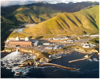
Construction on Pacific Gas & Electric’s Diablo Canyon Power Plant began in 1968. The first unit was commissioned in 1985 followed by the second in 1986. The plant is located about 12 miles north of San Luis Obispo, about midway between Los Angeles and San Francisco. Its two reactors are capable of producing 18,000 gigawatts of electricity annually, enough to supply electricity to more than 3 million northern and central California homes. Here’s a photograph of the plant:

When construction of the plant was started, engineers and regulators were well aware of the location of the San Andreas Fault (located 45 miles inland) and the Rinconada Fault (located 20 miles away). With that in mind, the plant was designed to withstand an earthquake that had a magnitude of 7.5. Unfortunately, engineers were unaware of a fault that virtually ran under the Diablo Canyon location. Geologists prospecting for Shell Oil Company discovered the Hosgri Fault, a thrust fault with some right-lateral slip motion, that runs just over 2 miles offshore from the plant. This fault is believed to be responsible for a November 4, 1927 seismic event known as the Lompoc earthquake that had a magnitude of 7.1. This earthquake is one of the most powerful earthquakes in southern California in the twentieth century. The tsunami produced by the earthquake was about 2 metres high and was noted as far north as San Francisco. This fault is located as part of the fault system along the plate boundary between the North America Plate and the Pacific Plate which is moving toward the northwest relative to the North America Plate.
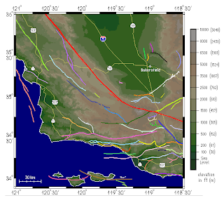
Here is a map showing the location of the Hosgri Fault (depicted in orange in the offshore area on the west side of the map) with respect to the San Andreas Fault (depicted in red):
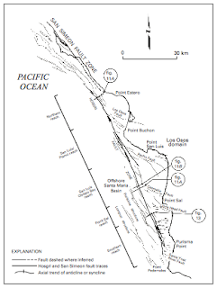
Here is a close-up map of the Hosgri Fault. Note the location of Point San Luis. It is located about 4 miles south of the Diablo Canyon Power Plant which is located right on the Pacific coast:
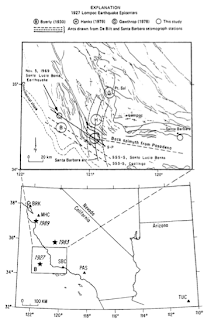
Here is a map showing the probable location(s) (depending on the seismological interpretation) of the 1927 earthquake located off the coast near Santa Barbara at the south end of the Hosgri Fault:
Fortunately, the Diablo Canyon plant sits 85 feet above sea level so it is relatively well protected from a tsunami. On site, PG&E has 4.5 million gallons of raw water storage and an additional 725,000 gallons of stored condensate and fire tank water should an emergency arise. Despite this seemingly ample protection, unfortunately, the plant is not quite as well protected from an earthquake. According to a New York Times article from October 1981, there was confusion in the use of transparent blueprints during construction which led to the improper placement of supports designed to protect the cooling systems of the two reactors. Apparently, the plans for installation of the safety supports for the twin reactors were depicted on a single transparency with plans for one reactor on one side of the blueprint and plans for the other on the opposite side. Unfortunately, someone forgot to tell those in charge of construction that they were to flip the transparency over. Oops!
The geology of the Hosgri Fault and its seismic record certainly do tell us that it is capable of a rather major earthquake. One also has to consider the possibility that an earthquake with a magnitude far greater than 7.0 could occur since seismic records do not exist further back than the 1880s when the first reasonably accurate seismometers were invented. While geoscientists do their best to predict the maximum magnitude earthquake that a fault can produce, they have no real way of knowing the past history of every major seismic event that has occurred along that fault over tens of thousands of years.
PG&E is currently in the process of applying to have its operating licenses extended for another 20 years. The license for Unit 1 expires in 2024 and the license for Unit 2 expires in 2025 so they are applying to have the plant remain operational until 2044 and 2045. By that time, despite the fact that PG&E has spent over a billion dollars on upgrades and updates, over 75 years will have passed since construction began on the plant. Here’s why PG&E wants its neighbours to support the application and postpone decommissioning of the plant:
“In addition to providing safe, clean, affordable and reliable electricity, Diablo Canyon is a vital economic engine for San Luis Obispo, if not all of California. As a major employer and purchaser of goods and services, Diablo Canyon has a total economic impact of more than $640 million annually for San Luis Obispo County and another $100 million for the state. The more than $25 million in property taxes paid by Diablo Canyon in fiscal year 2008-2009, helped support municipalities, schools and other crucial public services.
Furthermore, at PG&E, we strive to remain good neighbors to the communities in which we work and live. Diablo Canyon is no exception. Our employees make charitable contributions in excess of $250,000 annually to the community, which funds a wide variety of school programs, senior centers and many other critical community projects.
Yet, not all of the contributions are strictly measured in dollars and cents. Many of Diablo Canyon’s employees volunteer thousands-of-hours of their personal time to after-school athletic programs, environmental organizations, churches and other community organizations.”
There comes that warm, cozy feeling again!
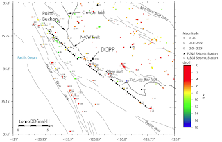
As if the proximal location of the Hosgri Fault weren’t bad enough, seismologists discovered a new strike-slip fault just off the coast near the Diablo Canyon Power Plant even closer than the Hosgri Fault. This fault, named the Shoreline Fault, was discovered in 2008. Here is a map showing the Shoreline Fault as a heavy dashed line, the Hosgri Fault and other faults in relation to the location of the power plant (labeled as DCPP):
As technology improves, it is likely that geoscientists will discover additional faults and gain a better understanding of their potential to cause damage to the Diablo Canyon Power Plant. Unfortunately, this possibility seems to have evaded the decision-makers who approved construction of a nuclear power plant in a very active tectonic setting in the first place.
Click HERE to read more of Glen Asher’s columns.
Article viewed at: Oye! Times at www.oyetimes.com
You can publish this article on your website as long as you provide a link back to this page.

Be the first to comment